


February 19, 2026
New methodology by Brazilian researchers employs remote sensing to map frost's impact on corn
Brazilian researchers have developed a methodology that uses remote sensing to map the impact of frost on corn crops.
This reduces exposure to climate risks and uncertainty regarding agricultural losses.
The model allows users to customise a set of variables, making it useful for other crops in different agricultural contexts. Thus, it has the potential to provide more accurate estimates during harvests and contribute to the development of public policies that support production chains and insurance systems.
Global grain production, particularly of rice, corn, wheat, and soybeans, is concentrated in just five countries: China, the United States, India, Brazil, and Argentina. Fluctuations in harvests in these countries can affect both prices and the global supply. These crops have also been affected by climate change, experiencing severe droughts, extreme rainfall, and more frequent frosts. This issue has been brought to negotiation rounds such as COP30, held in Belém, Brazil.
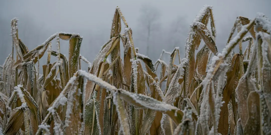
In the study, the scientists mapped over 700,000 hectares of corn planted for the second harvest in the western mesoregion of Paraná state (in the areas around Toledo and Cascavel) to identify damage caused by severe frosts recorded between May and June of 2021.
The scientists integrated optical remote sensing data (MultiSpectral Instrument sensor with medium spatial resolution aboard the Sentinel-2 mission satellites) with machine learning techniques (Random Forest algorithm). They achieved 96% accuracy in mapping corn crops and revealed that 70% were damaged by frost during that time. They were able to map the affected areas using the method they called GEEadas.
The results were published in the journal Remote Sensing Applications: Society and Environment.
"In 2021, we had a drought that disrupted soybean planting in Paraná and, as a result, delayed corn planting," said Marcos Adami, a researcher from the Earth Observation and Geoinformatics Division (DIOTG) of the National Institute for Space Research (INPE) and one of the authors of the article. "Then, in June, came the news of the frost. That region normally has high rainfall, which benefits crops. But we see that the climate in recent years hasn't been normal."
"A crop failure there greatly affects the lives of the people, most of whom depend on agribusiness. Developing this study is a way to provide tools that give answers and contribute to the planning of measures that help maintain this important activity."
Adami has been working with Professor Michel Eustáquio Dantas Chaves, from the Faculty of Sciences and Engineering at São Paulo State University (UNESP) in Tupã, for several years on remote sensing research focused on practical applications in agriculture.
"Producers still face a number of climatic uncertainties during the harvest, especially when there are extreme events, such as frost, which have social, economic, and environmental impacts," said Chaves. "In such cases, it's necessary to identify how much of the crop has been affected in order to inform the farmer, the banks that grant credit, or institutional bodies. This method provides accuracy, indicating the affected area and reducing uncertainties."
To validate the method, the researchers compared corn mapping areas and frost damage estimates with official data provided by the State Department of Agriculture and Supply. They also used information from insurance companies. Farmers typically file insurance claims to recover losses caused by adverse events. For each claim, an agricultural specialist visits the farm and analyses the damage.
"In the field, agricultural technicians have spatial limitations, which are natural to the activity. Seeing from above with remote sensing images allows us to complement the technicians' work," Chaves explained.
Adami said he is working with the National Supply Company (CONAB) in the states of Rio Grande do Sul, Paraná, and São Paulo to develop methodologies and collect data to obtain more accurate crop yield figures.
- Phys.org


